
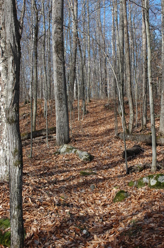
 A seldom used trail near downtown Saranac Lake.
 Introduction
The effort by the Adirondack Recreation Trail Advocates (ARTA) to create “a contiguous recreation trail from Lake Placid to Old Forge” is a laudable one. The concept of a recreation trail between these two communities on its surface sounds appealing. ARTA however has created the classic novel story line in that every good story has to have a protagonist, in this case ARTA, the good guys, and an antagonist, the bad guys, in this case the Adirondack Scenic Rail Road. Of course if you are the Adirondack Scenic Rail Road you may see it the other way around. History usually determines which is which. The winners end up being the protagonist and the losers the antagonist.
I prefer to look at it differently. I have an affliction called rationality. As one friend once wrote, “It’s Jack’s most honored virtue.” I like to find win-win solutions to problems. I’ve always preached to my students to use the rational decision-making/problem-solving process. One of the first steps of problem solving is to define the problem. It appears that the anti-train people define the problem as, we need more recreational trails in the Adirondacks, the railroad is a mode of transportation whose time has passed, so let’s tear up the rails and use the money from salvaging the iron and build a multi-purpose trail from Lake Placid to Old Forge. As a recreation professional with over 40 years of experience I see the problem a little differently. The problem, as I see it, is that most Adirondack communities lack easy access trails that you can reach from your home or motel room. The problem is, how can we remedy this? I’m continually amazed as I travel around the world how much easier it frequently is to find beautiful terrain to walk through in urban areas than it is in my hometown of Saranac Lake. That needs to change here in Saranac Lake as well as other Adirondack towns and villages.
The solution is much simpler than what the anti-train people advocate. The solution is a series of interconnected trails accessible from numerous access points. I’m going to suggest 10 trails for Saranac Lake as an example. I’m calling the list, “10 Trails We Should Build Before We Worry About Converting Rails to Trails.”
I’m going to share 1 trail a day here over the next 10 days with an accompanying map.
Before I begin let me make a few points.
Below is the map of trail number 1 and its description. Tune in tomorrow for trail number 2.
Jack Drury
The effort by the Adirondack Recreation Trail Advocates (ARTA) to create “a contiguous recreation trail from Lake Placid to Old Forge” is a laudable one. The concept of a recreation trail between these two communities on its surface sounds appealing. ARTA however has created the classic novel story line in that every good story has to have a protagonist, in this case ARTA, the good guys, and an antagonist, the bad guys, in this case the Adirondack Scenic Rail Road. Of course if you are the Adirondack Scenic Rail Road you may see it the other way around. History usually determines which is which. The winners end up being the protagonist and the losers the antagonist.
I prefer to look at it differently. I have an affliction called rationality. As one friend once wrote, “It’s Jack’s most honored virtue.” I like to find win-win solutions to problems. I’ve always preached to my students to use the rational decision-making/problem-solving process. One of the first steps of problem solving is to define the problem. It appears that the anti-train people define the problem as, we need more recreational trails in the Adirondacks, the railroad is a mode of transportation whose time has passed, so let’s tear up the rails and use the money from salvaging the iron and build a multi-purpose trail from Lake Placid to Old Forge. As a recreation professional with over 40 years of experience I see the problem a little differently. The problem, as I see it, is that most Adirondack communities lack easy access trails that you can reach from your home or motel room. The problem is, how can we remedy this? I’m continually amazed as I travel around the world how much easier it frequently is to find beautiful terrain to walk through in urban areas than it is in my hometown of Saranac Lake. That needs to change here in Saranac Lake as well as other Adirondack towns and villages.
The solution is much simpler than what the anti-train people advocate. The solution is a series of interconnected trails accessible from numerous access points. I’m going to suggest 10 trails for Saranac Lake as an example. I’m calling the list, “10 Trails We Should Build Before We Worry About Converting Rails to Trails.”
I’m going to share 1 trail a day here over the next 10 days with an accompanying map.
Before I begin let me make a few points.
- This list was created by me alone after spending less than an hour looking over a map of the region. I have hiked, skied, snowshoed, bicycled and/or snowmobiled almost all of these routes. The recently released Village of Saranac Lake Draft Bicycle + Pedestrian Trail Master Plan includes a number of these trails but unfortunately not all of them.
- This list is about multi-use trails but not all of these trails will be used by all modes of transportation. Some are possible to be used by all modes of travel but most will be limited to two or three. My effort was not to replicate the proposed multi-purpose recreational trail but to show that there are lots of trail development opportunities that the people of Saranac Lake should consider.
- These trails would be accessible from at least seven different trailheads but the trails would be interconnected so that users could access any trail from any one trailhead.
- This list will surely by criticized because of the many challenges to building some of these trails. Reasons like, there are too many regulatory obstacles. There are too many environmental obstacles. The cost is too high. You could say the same about the rails to trails project. Creative problem solving and good leadership can build all of these trails.
- My guess is that if you built all of these trails you will gain all the financial tourism benefits cited by ARTA’s studies.
- All distances are approximate.
- The order is random
Below is the map of trail number 1 and its description. Tune in tomorrow for trail number 2.
Jack Drury
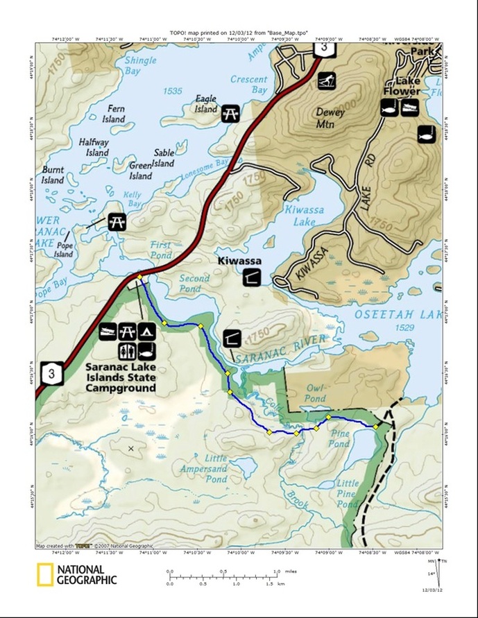
Name1. Saranac River -Pine Pond Trail | Access/DescriptionFrom the Route 3 State Bridge boat launch parking lot on Route 3 to the Averyville trail at Pine Pond Difficulty: From state bridge to Pine Pond - easy. From Averyville to state bridge - moderate | Distance3 miles | Thoughts/IssuesThe parking lot already exists. It would make a fine trailhead. A bridge across Cold Brook and that fact that it is a Wilderness Area are two issues. This trail would provide access to the existing trail to Averyville. |
| 2. Moose Pond Trail | From the Route 3 trailhead north of the village to Moose Pond and then around Moose Pond. Difficulty: Most activities - Easy Mountain Biking -Moderate | 4 miles | The trail from Route 3 to the pond exists. This trail in the McKenzie Wilderness should be made accessible by all but snowmobiles. (would need regulatory change to get bicycles) | Link |
| 3. McKenzie Pond Trail | From the Jack Rabbit trailhead on the McKenzie Pond road to the Waste Water Treatment Plan Difficulty: For most uses I would consider that a moderate trail. | 5 miles | From McKenzie pond to the Water Treatment Plan would be a new trail through a Wilderness Area. It should be made accessible by all but snowmobiles. (would need regulatory change to get bicycles) | Link |
| 4. Scarface to Pine Pond | From the Scarface mountain trail head on the Ray Brook Road following an access road to private property with a new trail over to Pine Pond. Difficulty: This is hard to determine. The trip from Ray Brook all the way to route 3 is relatively long but mostly downhill. The terrain is easy but the distance makes it more challenging. | 5.75 miles | Much of this trail already exists. This trail and #1 would provide access to the existing trail to Averyville. It could be a multi-use year around trail. It require only 1.6 miles of new trail. The rest already exists | Link |
| 5. Saranac River/ Moose Pond | From the Waste Water Treatment Plant to Moose Pond. Difficulty: Easy - This would be gentle terrain | 5 1/2 miles | This would be an all new trail through the McKenzie Wilderness . It should be made accessible by all but snowmobiles. (would need regulatory change to get bicycles) | Link |
| 6. Saranac Lake to Mt. View | From the Harrietstown Road north of Saranac Lake to Mountain View via the old railroad bed/Power line right of way Difficulty: Easy | 28 miles | It already exists as a snowmobile trail and could readily be turned into a multi-purpose year around trail. | Link |
| 7. Fowler’s Crossing Trails (Turtle Pond) | From the parking lot by the railroad tracks on route 86 this is a network of trails between Turtle Pond and Oseetah Lake. There are trails on both sides route 86. Difficulty: Easy - perfect for novices of all kinds | ~2 miles on the west side of the tracks ~2 miles on the east side of the tracks ~1.75 mile spur to the Scarface Mt trail. | This network exists. It just needs to be formalized. It could be a multi-purposed year around trail although probably would not be of interest to snowmobiles due to its short length. This would include a new spur to intersect with the Scarface Mt. trail. | Link |
| 8. Scarface Mountain Loop | From the existing trail on the summit of Scarface Mt. around the eastern ridge down to Ray Brook across the tracks out the access road on the NE side of Scarface to Route 86. Difficulty: Challenging | ~6.5 miles (2 miles of new trail) | I've bushwacked this route and variations of it numerous times on foot, snowshoes, and skis. This could be used as a year around non-mechanized trail. (i.e., not snowmobile, or bicycle) | Link |
| 9. Lower Saranac Lake Trail | From the Route 3 State Bridge boat launch parking lot around the south end of Lower Saranac Lake crossing the river at the upper locks then proceeding around and eventually heading north to the Forest Home Road.Difficulty: moderate | ~ 9 miles | This is Wild Forest so could be multipurpose year around trail although for a number of reasons it might not be practical for snowmobiles. It follows a number of existing hunting trails and even a portion of an old snowmobile trail. The main challenge would be building a bridge across the Saranac River near the upper locks. The State Bridge on Route 3 has great potential as a trailhead since a parking lot already exists. | Link |
| 10. Black Pond Trial | From the Forest Home Road to Black Pond and then intersecting with the Lower Saranac Lake Trail. Difficulty: Hiking is moderate Skiing is challenging Mt. Biking is challenging | >4 miles | This is Wild Forest so could be a multipurpose year around trail although for a number of reasons it wouldn't be practical for snowmobiles. A hunter/fisherman’s trail already exists to Black Pond. | Link |
 RSS Feed
